All The Civilization You Need


IMG_0631

Hanging out at Taggart Lake located within Grand Teton National Park


About sixty miles south of Grand Teton National Park is Pinedale, WY. Their official slogan is “All the civilization you need!” Not so sure about that one, but the town does have a nice deli, a brew pub, and the very interesting Mountain Man Museum.

It was a wonderful week spent camping at our favorite national park. On Sunday we rolled into the less popular Gros Ventre campground then bolted the next morning to Signal Mountain. We arrived on August 7th which, given the fourteen night maximum stay, meant we could have planted ourselves right smack dab in the solar eclipse path. That is in fact exactly what many of our neighbors did. But after six weeks traveling the country we were itching to get back to our non canvas home.


DSC_0766

This bridge outside of Pinedale is designed to help give antelope safe passage across the highway during their annual migration


IMG_0613

Although at times smoky from the nearby wild fires, we do love the Tetons


IMG_0623

Henna watching the sunset a short walk away from our campsite


DSC_0716

Natural Bridge near the south entrance at Yellow Stone National Park


DSC_0731

This raven was not amused by the crazy crowds at Yellowstone

IMG_0638


A Few Thoughts While Sitting on My “Porch” in Missoula, MT


DSC_0676

Noel’s Front Porch (Missoula, MT KOA)


It’s not exactly a porch. I am actually sitting on my former camping chair (Henna stole it from me just before we left town) just in front of my car and facing the campground road. Across from me are two adorable little girls helping their dad/grandpa take down the tent. Every few minutes someone walks by and we wave hello to each other. Just now another family walks by with a puppy and the two girls go nuts. Did I mention that I already skimmed the “Missoulian?” It was delivered to my tent sometime before I woke around seven. Although a bit transient, this is really a nice little town.


DSC_0674

Northwest Highway/ U.S. 12 along the Lochsa River in Idaho


So if you take Northwest Highway (which we take several times a day when we are not camping across America) and go through Park Ridge and then Des Plains and then choose Rand Road and then keep going through Wisconsin you will, after a few days, eventually reach us. And maybe, just maybe, Corey and Henna will be awake.


The Magical Campground and Other Wonders of Coastal Oregon


DSC_0612

The magical campground in Garibaldi, Oregon which is located on the grounds of a former mill. Besides being a fountain of free crab meat the place also supposedly never fills up due to its large size.

I call the big sprawling campground in Garibaldi, Oregon (about 55 miles south of Astoria) magical mostly because of the free crab meat. Patty, the caretaker/campground angel, brought us over four whole soft shell crabs as a thank you for visiting Oregon (and also because her grandson, like us, lives in Illinois). Already cooked, she cleaned the shell fish in front of us and we were good to go. Then the next morning our fisherman neighbor gave us another crab for the road which we later clumsily cleaned for lunch.

Besides crabs, coastal Oregon gave us plenty of good conversations including one with our (we hope) future selves. It happened at the farmers market in Newport, Oregon where the food stalls were all a family affair with little kids helping their parents serve up delicious eats like kimchi and gourmet grilled cheese sandwiches. Twice in Newport we told someone that we were from Chicago and they immediately mentioned “Wait Wait…Don’t Tell Me!” My parents remember a time when people associated Chicago with Al Capone. In the 1990s it was Michael Jordan. Now it’s Peter Sagal.

Anyways, while sitting at a picnic table eating our Japanese noodles and grilled cheese sandwiches, this couple sat down next to us and we began to talk about campers. They had made the leap from tent camping to recreating in a modified, fully self-sufficient Sprinter camper. They also exuded a genuine calming aura that lulled us completely out of our petty trip related concerns (specifically where we were going to spend the night) and into the present. Just prior to lunch we contemplated paying $60 to camp at the KOA in Astoria. This would be by far the most we ever paid for a campground but given the scarcity of campsites over the weekend it seemed a better choice than maybe paying twice that for a motel. After talking to our new friends we knew that was crazy. So instead we ate lunch, strolled the waterfront (one side of the street Ripley Believe it Or Not museums and t-shirt stores, the other a working dock), and then meandered down the road. Later we discovered the magic campground and met Patty. I cannot think of a better way to finish the Oregon coast.


Corey on the Coast

Corey hanging out by Seal Rock


DSC_0629

The Peter Iredale which ran aground at Fort Stevens State Park a century ago


respect the ride photo

Always remember to respect the ride. Photo courtesy of Google images (and taken in Portland)


Bear Encounters and Other Stories Along the California and Oregon Coast


IMG_0344

The Oregon Coast


IMG_0306

Angry at the both of us, Corey put Henna and I in time-out at Redwood National Park


So there we were in Redding, sweating it out at 100+ degrees, and having to decide whether to 1) go up Interstate 5 to Mount Shasta and then Crater Lake or 2) hit the coast. We chose the latter and then spent four lovely nights camping from the Redwoods near Eureka, CA to the gentle waters of Sunset Bay, Oregon. In California, at a private campground, my full bladder woke me in the middle of the night. While taking care of business I looked up and saw a very large bear less than fifty yards away from me. The bear was sniffing the grass like the skunks do by my house in Chicago. He/she did not register me in any way. I went back to the tent and then debated whether or not to wake up Corey and Henna. They were sleeping soundly, the bear did not seem out for tourist blood, so I tried to go back to sleep. Twenty minutes later I peeked out the tent and the bear was nowhere to be seen. It took me at least another hour to fall back to sleep.

DSC_0538

That was actually my second bear encounter or third if you count the time in Ouray (a small bear ran through the campground near our tent). The other encounter was in Plumas-Eureka State Park. Corey and Henna drove to the main visitor center but I decided to walk the pleasant mile and a quarter along a creek trail. About halfway down the trail I came across three women walking together. In response to hearing my footsteps behind them they whirled around to face me. One lady was carrying a heavy branch. They told me there was a sow and a cub just up the trail. There were four of us so we decided to walk forward. As we did so I told a joke that I have heard my dad tell dozens and dozens of time about two boys being chased by a bear. The punchline is that one boy tells his friend that he only has to outrun him (and not the bear). The joke went over well and I never actually did see either of the two bears (although supposedly they watched us the whole time).


IMG_0373

A great cup of coffee in Langlois, Oregon led to us finding one of Oregon’s premier kite surfing destinations.


We met a lot of other really cool people. Sometimes though the conversations went a little off. Like the ranger we met who, when told we were from Chicago, assumed that we had seen the last Grateful Dead show (Jerry Garcia died shortly after playing Soldier Field). Corey actually was at that show and so joked “I actually killed him.” Dead silence. Or, again in Plumas, I told a woman that it was a three mile hike to Rock Lake. She then asked how long it was round trip.


IMG_0387

Our third massive sand dune of the trip was at Oregon Dunes National Recreation Area.


This is likely our last night on the coast and is spent at a motel a little south of Newport. As for tomorrow, well, who knows where we will go.


IMG_0380

Blueberries are might tasty on the coast of Oregon


Fire and Snow in the Sierras


Henna in the haze

A hazy sunset over Lake Tahoe


A trio of eagles perched over Lake Tahoe

A trio of eagles perched over Lake Tahoe


After spending some time on the Loneliest Highway we were a bit overwhelmed by the over loved (and, yes, very beautiful) Lake Tahoe. Heavy traffic everywhere and most hikes involved a lengthy weight just to park the car at the trail head. There also was quite a bit of smoke coming from forest fires both to the east of us as well as from the Yosemite area. Our original plan in fact was to head to Yosemite but all that smoke pushed us north into Plumas Eureka State Park. Located at about 5000 feet, temps reached the mid 80s during the day but then dropped twenty degrees at night. We camped there three nights and saw more shooting stars than clouds. And the only thing better there than the hiking was the mountain lake swimming. Leaving the state park we headed to Lassen Volcanic National Park where we saw 1) a helicopter rescue from the visitor center (no idea what happened) and 2) a lot of snow. And by a lot of snow I mean snow banks over ten feet high. The main park road usually opens mid-May or early June. This year it opens up in a few days. So we drove as far up as possible then walked a bit on the eerily quiet pavement. Maybe a few snowballs were also thrown. Then less than ninety minutes later we were chillin at a hotel in Redding where the temperature outside is over a hundred degrees. If you want consistency then stay out of California.


DSC_0490

One more sunset picture


IMG_0203

Swimming at Rock Lake in Plumas Eureka (3 mile one way easy to moderate hike with great views of the Sierras and one awesome mountain lake to swim in).


IMG_0204

Remnants of the Jamison Mine which operated into the 20th Century. Cool outbuilding and other artifacts can be found throughout Plumas Eureka State Park.


DSC_0506

Your safety is never guaranteed. A helicopter rescue from a visitor center at Lassen Volcanic National Park. The helicopter landed in the corner of the parking lot about 25 yards from where we stood.


As far as we could go

Due to the heavy snow that fell last winter car bound traffic (for now) can go no further although cyclists and hikers are allowed as far as they want to go.

IMG_0249

IMG_0260


IMG_0261

Mountains + wild flowers = deep contemplation


The Loneliest Highway: Route 50 through Nevada

DSC_0430


DSC_0424

Our first night in Nevada was spent camping in Baker. Although at 5000 feet elevation, Baker remained very hot (mid 90s) until dark. It was a dry heat though and all we needed was a bit of shade to be comfortable.


First called the “Loneliest Highway” by Life Magazine in 1986, Route 50 through Nevada does indeed offer plenty of solitude. Beginning in Baker (population 68) and then ending at Carson City (over 50,000), Route 50 also contains one amazing national park, several mountain passes (we lost count after six), and many historical or just plain weird features. And in the end we find ourselves a stone’s throw away from Lake Tahoe and the Sierra Nevada Mountains.

glacier

Rising 8000 feet above Baker (and 13,000 feet above sea level) is Mount Wheeler which is within Great Basin National Park. We camped at around 10,000 feet which allowed us to easily hike up to a bit of snow (and a killer view of the desert below).

DSC_0455

The historic and recently restored Eureka Opera House. Gold mining continues to be the life source for this very friendly and remote town.


castle

The Stokes Castle in Austin, NV was built by a very wealthy banker and railroad magnate for his wife in 1897. They spent one summer in the castle and never returned.


DSC_0473

The Pony Express went through parts of Route 50 including near Cold Springs, Nevada where there now sits a nice gift shop/bar/café.


DSC_0472

Seasonal wild fires burn the sage brush and weeds. This scorched earth appeared just east of Cold Springs.


DSC_0476

Our second sand dune of the trip, we had Sand Mountain entirely to ourselves. The mid 90s heat though kept us off the sand.


People We Meet Along The Way: Abby and Danny

danny and abby

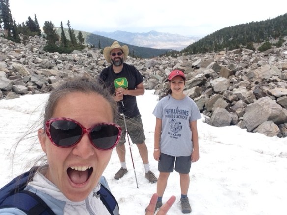
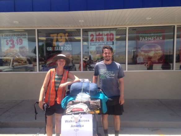
We met Abby and Danny at a gas station/Burger King in Green River, Utah which is just off Intestate 70 and a little west of Moab. Leaning against the window was a makeshift stroller loaded with assorted camping gear and a jug of water. Dressed with almost as much dust as clothes, there was no mistaking the owners of that stroller.

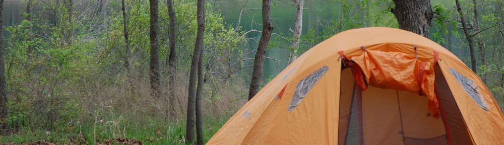
Beginning from Long Island, NJ in March, Abby and Danny have been walking across the country 20-30 miles a day. They hope to reach San Francisco in mid-September. For most of their journey they have walked the backroads, but since entering the west (which allows people to walk the interstate) they have taken to the shoulder of the highway. The heat right now can be a killer which has forced them to walk more in the relatively cool morning. On the day we met them they were hunkering down at a motel. Most nights, however, have been spent camping on public land, in backyards, and wherever else the road leads.

This journey is in part an effort to raise awareness and fundraise for the homeless (Abby and Danny first met while working with a non-profit via AmeriCorps).  But they are also walking in order to meet people, gain insight into our country, and for the mental and physical challenge. From their webpage (walkacrossamerica2017.com) they also seek to slow down their experiences and call walking the “poetry of transportation.”

Among the many funny experiences they have had while walking the road has been repeatedly being upstaged by a goat. Apparently a man, with a goat, recently walked across American. Several times at the beginning of their trip, Abby and Danny walked into a town recently visited by this unusual pair. Each time the town folks asked is they were traveling with any animals and then were disappointed when told they were not.

After meeting Abby and Danny, the three of traveled the one hundred miles or so between Green River and Salina, Utah where we stopped for ice cream and coffee. Other than several rest stops, there are no services on this lonely stretch of Interstate. The speed limit is 80 miles per hour. It will take Abby and Danny at least four and likely five or six days to cover the same distance. We worry about whether they will find good shelter as well as water and food. In doing so, we also cannot help but think of the millions of homeless living both on the streets of the U.S. as well as in refugee camps around the world. Maybe, just maybe, their voyage will raise empathy as well as money.


DSC_0412

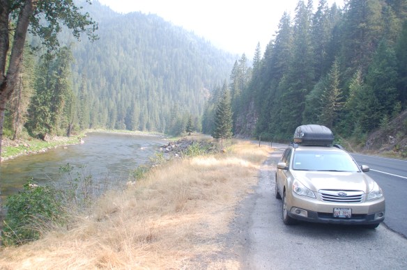
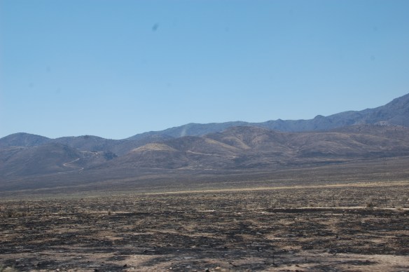
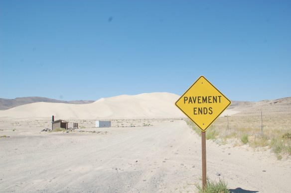
Route 50 in Utah (imagine walking this stretch for days)


You can follow Abby and Danny’s amazing journey via their webpage here. You can also follow them on Facebook or help the homeless by donating to JOIN: Connecting the Street to a Home which is a non-profit serving the Portland, Oregon community.


It took us a little over two hours to travel the one hundred miles from Green River to Salina, Utah. This stretch of Interstate 70 has several rest stops, but no other services. It will take Abby and Danny at least four days to travel the same distance. Whereas we sped along at 80 miles per hour on the good four lane highway, they will be walking along the shoulder. Between them they have a modified stroller which is overburdened with essential gear such as sleeping bags, a tent, and lots of water and food. Every two hours or so they trade places pushing the stroller along.


Santa Fe to Ouray, CO


upload for blog

At Meow Wolf


Before leaving Santa Fe we visited Meow Wolf which is sort of like a fun house meets contemporary art meets the Upside Down World from Stranger Things. It was awesome.

Afterwards we drove about ten miles and camped above Santa Fe in Hyde Park. Despite being just a crazy downhill bike ride from the Plaza, the state park felt remote and offered up many cool trails into the mountains. There was no running water but most sites had a pretty nifty three sided picnic shelter. While camping there we discovered two tears in the rain flap. Not good. But a few days later we bought Henna a sewing kit and she fixed the problem. Thanks Mrs. Cecilia!

Then we headed to Ghost Ranch where Georgia O’Keeffe completed a lot of her work. A lot of movies including Silverado and City Slickers were also filmed here. It’s now a sprawling campus of multiple museums, lots of trails, and a lot of different ways to spend the night. We though chose to move along and drove some of the loneliest miles we have ever driven to Bloomfield, NM where we camped at a former KOA. The place was nice but was surrounded by too many angry/barking dogs to be peaceful. And then we drove to Ouray.


IMG_9899

Hiking at Ghost Ranch


The Million Dollar highway, so called either for its views or for the value of the ore extracted from the surrounding rock, drops down from Durango to Ouray. It is a scary white knuckle ride even in the best of conditions. We began in a light rain that soon turned to hail and a downpour. Waterfalls ran heavy to the road and I hoped the AWD would keep the car from skidding. Worse were the rocks which came down in one section and cracked our new windshield and dented our hood.


IMG_9921

The former mining town of Silverton which rests at over 9,000 feet


The rain continued in Ouray and we sat a long time at the KOA debating what to do. At one point I went to the bathroom (individual unisex stalls) and was locked in. It took a few minutes of me banging on the wall before someone was able to get me out.


IMG_9960

Along the Perimeter Trail in Ouray


The rain eventually stopped and we had a great dinner at a Brew Pub. We also, for the first time in a week and a half, spent two days in one place. It felt good holding still.

IMG_9914

Taos and Santa Fe: Pueblos, Earthships, and Motels


earthship photo

One of the more whimsical Earthships located just outside Taos, NM


After a sandy morning we left Great Sand Dune National Park and then had a killer breakfast in Alamosa. Refreshed we drove south to Taos where, just outside the city limits, we stopped to tour an Earthship. No, we were not smoking any Colorado weed. Earthships, unlike Starships, are very much real. First conceptualized by architect Michael Reynolds in the early 1970s, Earthships utilize recycled materials such as tires as well as solar panels and water filtrations systems to create completely off the grid homes. Rain water, for example, is funneled from the roof into a system that uses the resource multiple times. Much of the living space is also below ground which helps regulate the temperature. The model we were allowed to tour was comfortable, cool, and had a very hip southwest feel. It is hard to pin down exactly how much one of these cost but a quick google search found a 1900 square foot home selling for half a million and a much smaller Earthship priced under $200,000.

IMG_9735

Taos was a bit too crowded for our tastes. And overbooked. Regrouping we opted to “plan ahead” which meant that I called a motel in Santa Fe that the three of us stayed at over a decade ago. They only had a few rooms available so we “made reservations.” Knowing then that we had a place to stay we decided to check out the Taos Pueblo where we lingered a bit before taking the very dramatic 70 mile drive south.

DSC_0247

Ruins of the original church built by the Spaniards in 1619 but then destroyed during the Spanish Revolt of 1680. Later rebuilt it was destroyed once more by the United States Army in 1847 which at the time was at war with Mexico.

In Santa Fe we showered, went to bed at a reasonable time, and then spent a wonderful day wandering one of America’s oldest city. At night we chilled in the Plaza and listened to some great music by The Battle of Santiago who describe themselves as a “Canadian Afro-Cuban post rock band.” They had us dancing in our lawn chairs.


20170708_211034

Hard to take a bad picture in Santa Fe


So now we are rested and one week into our trip. Tomorrow we will be…. I don’t know. And it feels good to say that.


IMG_9767

Henna at our temporary home, the Garret Desert Inn in Santa Fe


Great Sand Dunes National Park

FullSizeRender

The clues were as follows: a citronella candle, a few sticks of firewood, a half finished “Polynesian” flavored barbeque bottle, a bottle of bug spray, and a bit of charcoal. All items were found within the campsite’s bear box (a metal box with a trick lock that both frustrates hungry bears and, due to it’s loud creaky noise, is guaranteed to wake up anyone sleeping within a seven campsite radius). We took a pass on the sauce, but the firewood came in handy. What did we do to deserve such generous gifts?

The campsite’s other riddle was easier to solve. To our annoyance, several very large boulders were scattered about like Stonehenge exactly where we hoped to set up our tent. So first we had to move the rocks, then we set up our tent, and then we attempted to stake it all down. But sand makes a very poor foundation and, thus, we had to pick up those same pesky boulders, which by this time where heavier, and use them to keep down the tent.

So back to the clues. After a long day of sand hiking, sand sitting, and sand staring we proceeded to make a fire. Dinner was fine and then, like a plague out of Egypt, the mosquitoes descended upon us. The smart one, Henna, retired to the tent but Corey and I valiantly lit our one citronella candle (thanks Tim and Linnea) which seemed to do nothing but irritate the little buggers. Defeated we joined Henna.

A few hours later came the winds. Powerful winds that blew sand into our tent and at times actually seemed to almost lift the tent a millimeter up. Our poorly grounded rain flap became unbound and flapped like a loud bird. Corey and I had to yell to be heard and twice we courageously ventured outside only to return with sand in our eyes. It was immediately after one of these episodes that we suddenly understood the true nature of the objects. They were not gifts so much as objects left behind in fright.


DSC_0236

DSC_0238